11th Street Station
South Shore Line
Michigan City, Indiana
Last Updated: October 2023
TOD Strategic Implementation Plan
Following the TDD boundary being established October 31, 2022, the team worked closely with the City of Michigan City to identify and collaboratively advance planning for the community to be proactive about future TOD.
At the conclusion of this process, control of local land use and zoning remains with the cities and towns. This process aims to provide proactive guidance and recommendations that the local units can use to advance their planning processes, resulting in updated comprehensive plans, area plans, and zoning ordinances complete with locally-controlled public input.
Community Priorities & Opportunities
Big Moves
“Big Moves” are defined as enabling steps to signal to the market that conditions are right for transit-oriented development to occur.
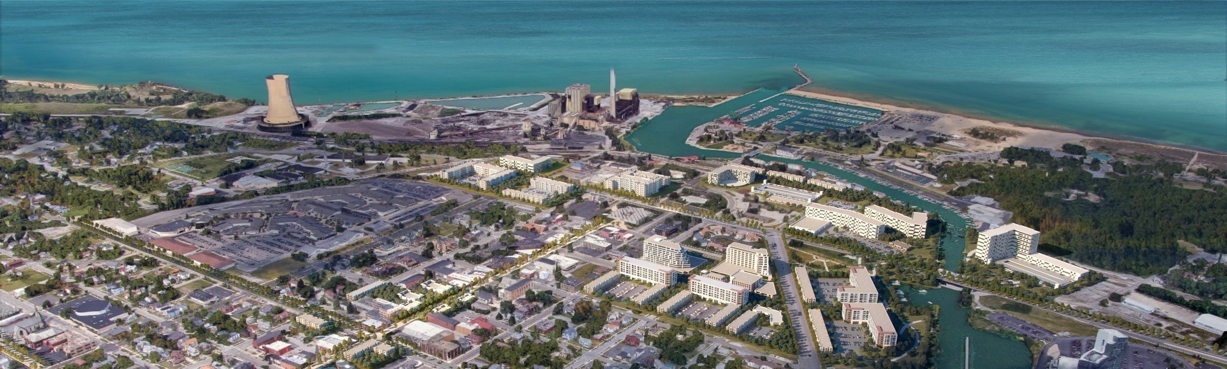
Community economic development goals and priorities for future investment in the TDD boundary where considered in the formation of “big moves” which represent the greatest opportunities for TOD in the community. The City of Michigan City aims to prioritize mixed-use transit-oriented development around the 11th Street station (coinciding with the realignment of 11th Street and the South Shore Line), investment in the Franklin Street commercial corridor, and development of underutilized sites near Trail Creek to establish a waterfront destination.


Areas of Impact
Areas of Impact were established to distinguish between major (re)development areas, both TOD and non-TOD, and areas to be maintained, preserved, and enhanced. These designations begin to direct development activity and other targeted investments based on proximity and relationship to the station area.
TOD opportunities include blocks directly adjacent to the upgraded 11th Street Station, along Franklin Street, and throughout downtown. TOD at the station is envisioned as dense, mixed-use development being led by the current development project at the station. Underutilized properties near the Elston Center could be developed as neighborhood sensitive infill with frontage along Franklin Street. As it has been considered in the past, reuse and/or partial redevelopment of the former St. Anthony's Hospital site presents another opportunity for neighborhood-scale infill. Sites along Trail Creek also have the potential for high-impact development that can activate the riverfront downtown and support TOD.


Future Land Use
The approach to future land use planning in this plan focuses on areas that are anticipated to change. Future land use is shown in general categories of land use to guide future land use and development decisions while allowing for flexibility in densities and building types.
Immediately surrounding the 11th Street Station and rail corridor, Mixed-Use Joint Development is planned that combines mixed-use with rail commuter parking. Additional areas along 11th Street corridor will be Station Area use as additional commuter surface parking. Future land uses along the Franklin Street corridor from 11th Street to 4th Street and key waterfront sites are envisioned as Mixed-Use Core, which will create higher density mixed-use development. Further south, Mixed Residential uses are planned on underutilized sites within existing residential areas. Infill opportunities along Michigan Boulevard exist as future Neighborhood Commercial. A portion of the St. Anthony’s Hospital will remain in medical-related operations as Employment/Office uses, while other portions may transition to Mixed Residential. Over time, there is potential for the Lighthouse Place Premium Outlets to redevelop as Mixed-Use Neighborhood.
Land Use Planning


Development Planning
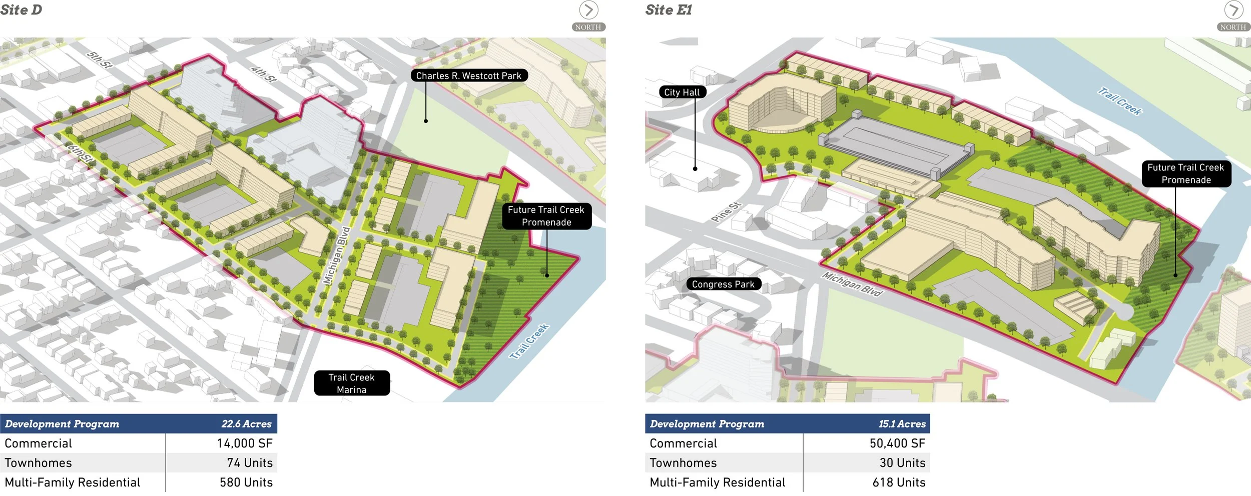
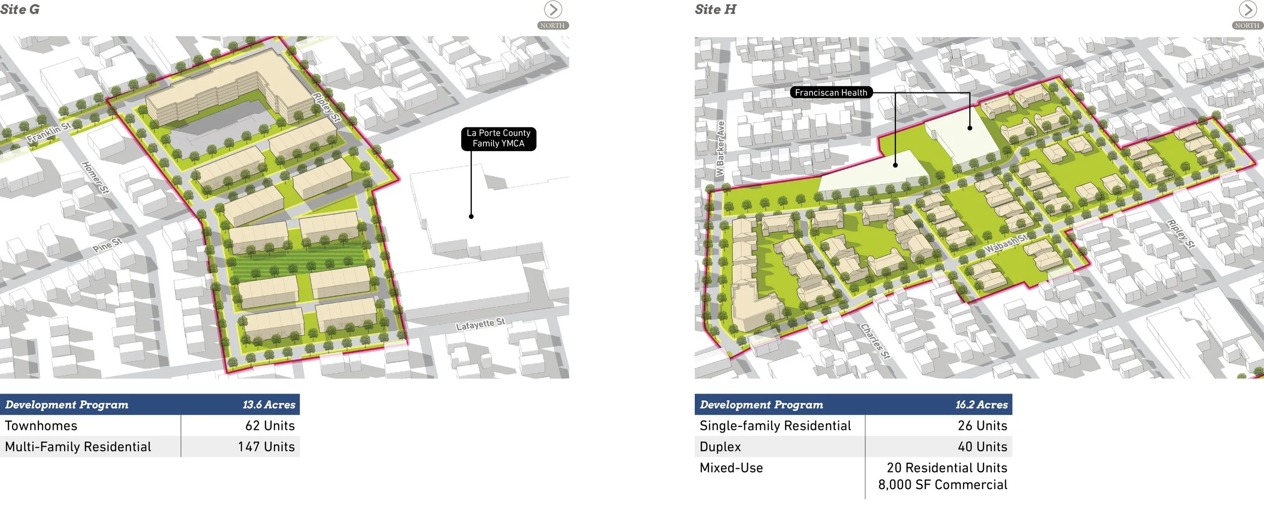
Development Concepts
Nine development opportunities were studied in this planning process and selected to illustrate the potential of TOD in more detail with scenario planning and renderings.


Conceptual Rendering of development between the 11th Street Station Area and the waterfront.


Conceptual Rendering of development between the 11th Street Station Area and Barker Avenue.

Conceptual Rendering of development around the 11th Street Station Area.
Arc of Development
The arc of development for each community was defined collectively for selected development opportunities within the TDD boundary that projects future development potential over 5-, 10-, and 20-year time horizons. Quantitative and qualitative factors such as local/public property control, developer engagement or interest, site conditions, current regulations or future regulatory changes, among others were considered.

Infrastructure
Thoroughfare Typologies
Thoroughfare Typologies were developed to analyze existing corridor conditions and create aspirational goals for future street design and streetscape.


Thoroughfare & Streetscape Design
Further studies were conducted on TOD Priority Thoroughfares at the request of the local units. These studies and the corresponding order of magnitude cost estimates are included in determining possibilities for infrastructure improvements that could catalyze TOD close to the station.


TOD Priority Thoroughfares
Franklin Street and 11th Street are designated as TOD Priority Thoroughfares as they are and continue to be major activity corridors for downtown and the station. With the rail realignment project, 11th Street will receive a redesign and streetscape enhancements. TOD Connectors, including 2nd Street, Pine Street, Washington Street, and portions of Franklin Street and 11th Street, promote connectivity to the station area throughout downtown. Other important connections made by Key Vehicular Routes, such as Michigan Boulevard, 8th Street, Chicago Street, Wabash Street, Barker Avenue, and Greenwood Avenue, carry traffic between downtown and the surrounding residential neighborhoods.


The first phase of redesigning Franklin Street proposes converting the section north of 9th Street into two-way traffic by restriping travel lanes and angled on-street parking on the west side. The second phase includes landscaped bump-outs at intersections, enhanced crosswalks, landscaping, and pedestrian amenities.


At 9th Street, the centerlines of Franklin Street on either side of the intersection must be re-aligned.
Between 9th and 11th Street, the design concept includes reduction of travel lanes, parallel on-street parking, and enhanced pedestrian amenities.
South of 11th Street, a lane reduction is proposed along with landscaping, a planted median where appropriate, bump-out at pedestrian crossings and enhanced pedestrian amenities.
Questions or Comments
Fill out a comment card - Contact Us
Check the FAQ section
Read through the questions below from the virtual public meeting
Browse through more information on the site which is constantly being updated
Virtual Public Presentation
Review the full slide deck and video recording from the Virtual & In-person Public Presentation on June 23, 2021:
RELINK BELOW

Q&A
When does the city council have to approve the MOU? Before or after the 2 public RDA meetings?
The MOU will not be constructed until the RDA publishes a resolution defining the boundary after the 2 public RDA meetings. This will be taken to the state budget committee for approval.
Are there constraints on what TDD revenues can be used for?
The primary constraint is where they can be used: within the district. They can be used for capital projects. For example, a hotel goes in with sidewalks needing to be placed within the district. The walkway to the hotel would be a capital need to facilitate the hotel.
Does the TDD plan decided by each city have to be approved by the state budget committee?
In short, no. The state budget committee reviews the boundary itself, but it is not the development desired that gets decided upon by the state. The state must approve the boundary itself because it has approved for incremental local income taxes to be collected within the district, which involves the state budget committee’s involvement. The kind of development decided upon within this boundary, however, is purely a local decision.
Do TDD and area funds take money away from the general city find?
No. It is only the increment (the growth) inside the TDD district that would not take place without the incentive of the fund which would be used for development. This could take place in the form collection of property or income taxes incremental increase. This mirrors the way a TIFF district functions.
Can TDD revenue be used to connect other parts to the TDD district? (Increased municipal transportation.)
Increased transportation opportunities are a key aspect of the TDD. However, public transportation development via TDD revenue will be limited to capital needs, not operating needs. The revenue may be used for a mode of transport which will increase capital in the district but is not to be used to purely operative needs in the community.
What is the life expectancy of a TDD? Can the boundary be altered in the future?
This cycle would be in place until 2047, if approved. The boundary has a one-time opportunity in each community to double in size.
This project is so huge, it is difficult to completely comprehend…NIPSCO property may be available in 2028: if so, are you looking at development of PS or office?
We are trying to set the initial 320 acres at this time. If and when the NIPSCO property becomes available, that may be an appropriate time to consider applying for your community’s TDD doubling. We have not put that property into our initial draft boundary because we feel an opportunity as large-scale as NIPSCO would most likely require use of years of incremental revenue development via the TDD in order to achieve its full potential.
Read in today’s paper that the prison might relocate. Would that be included?
The prison lot is not currently captured within that boundary.
What about new road connections to Porter County?
Revenue collected within the Michigan City boundary must be used within that same district; thus, it would not be used for development in areas outside of Michigan City.